When urban stormwater meets high groundwater – Part 2
Thompson, M Shanafield, A Manero, G Claydon.
First published in Water e-Journal Vol 6 No 1 2021.
Abstract
New land releases in the Perth Region on Western Australia’s Swan Coastal Plain are increasingly constrained by seasonally high groundwater (within 4m of the land surface). The measurement, modelling, and management of the effects of urbanisation in these high groundwater environments remains a challenging problem. To address this problem, the Cooperative Research Centre for Water Sensitive Cities (CRWSC) funded the “Knowledge-based water sensitive city solutions for groundwater impacted developments” Integrated Research Project, IRP5. In 2019, this project convened an Expert Panel to assess best-practice, and make recommendations to land development, engineering consulting, regulatory and advisory stakeholders. The Expert Panel explored strategies for groundwater risk assessment and provided technical guidance for measuring, modelling and predicting changes in groundwater as urbanisation progresses. It also obtained extensive input from stakeholders on the need to reduce the costs and risks of urban development in sites with high groundwater. In this paper, we argue that, by integrating technical best-practice groundwater assessments with design innovations and reforms to governance, urban development on high groundwater sites on the Swan Coastal Plain can minimise the current reliance on large volumes of sand fill. Although challenging, shifting to a low-fill development paradigm would represent a triple-bottom-line “win” for developers, homeowners and the environment.
Introduction
In Australia, and elsewhere across the world, urban stormwater design has grown and matured enormously in the last 20 years. Achievements include the development of national standards and guidance on modelling and risk assessment (Ball et al., 2019), innovation in water sensitive urban design (Brown et al., 2016), and extensive work to reduce the impact of urbanisation on the natural environment while maximising quality of life for residents (Radcliffe, 2019).
Nonetheless, certain aspects of urban water management still require further work. For example, the optimal management of urban water cycles and urban development in the presence of high groundwater has received relatively little attention (see Part 1). This issue is globally relevant, given that high groundwater (also referred to as shallow groundwater) influences 22 to 32% of the global land area (Fan et al., 2013). Importantly, 40% of the world’s largest cities are located over conditions that promote high groundwater, including shallow bedrock (<10m) or local and shallow aquifers (Richts et al., 2011). Under such conditions, the risk of groundwater flooding increases, with potentially serious impacts for residents. For example, recent groundwater flooding in Stuarts Point, NSW, resulted in septic systems being filled up and spilling sewage onto the streets (ABC, 2021).
The city of Perth, on the Swan Coastal Plain in Western Australia, provides a relevant case study of urban development across areas affected by high groundwater. New land releases in this region are increasingly constrained by seasonally high groundwater. The measurement, modelling, and management of the effects of urbanisation in these high groundwater environments remains a challenging problem. To address this problem, the Cooperative Research Centre for Water Sensitive Cities (CRWSC) funded the “Knowledge-based water sensitive city solutions for groundwater impacted developments” Integrated Research Project, IRP5 (CRCWSC, 2017). In 2019, this project convened an Expert Panel to assess best-practice, and make recommendations to the land development, engineering consulting, regulatory and advisory stakeholders. The Expert Panel’s mandate and methodology are summarised in Part 1, including the resulting groundwater risk assessment and technical guidance for measuring, modelling and predicting changes in groundwater as urbanisation progresses. While these issues are pertinent to the prediction of groundwater dynamics in urbanising sites, minimising the costs and risks associated with development in sites with high groundwater also requires attention. As we argue here, improvements in this area will require integrating technical best-practice groundwater assessments with design innovations and reforms to governance. Although challenging, achievable changes offer scope for a triple-bottom-line “win” for developers, home-owners and the environment.
The aim of this paper is to present the findings from in-depth case studies, highlighting the critical issues affecting the use of sand fill in high groundwater areas in the Swan Coastal Plain.
Methods
Between September 2019 and April 2020, an Expert Panel was convened to provide guidance on best-practices for monitoring, modelling and managing high groundwater in urbanising areas within the Swan Coastal Plain. The research conducted by the Expert Panel consisted of two parts. First, a literature review was carried out to understand the current state-of-knowledge and knowledge gaps. See Claydon et al. (2020) for the full CRCWSC report. Second, a series of in-depth surveys were undertaken to understand (i) current best-practice; (ii) most commonly applied practices across the industry; and (iii) practices that could be improved. Purposeful sampling methods were used to identify individuals and organisations with particular expertise in high groundwater in urban areas on the Swan Coastal Plain. The intentional sampling approach (as opposed to probabilistic sampling) is appropriate for qualitative, exploratory studies, where the aim of the research is to gain in-depth insights into a particular subject (Palinkas et al., 2015). Participants of the case studies included members of four local government authorities (LGAs), seven consulting firms, one state government department, as well as two research academics. Confidentiality of participants’ identity and information provided was strictly observed, in line with the University of Western Australia (UWA) ethics protocol (2019/RA/4/20/5775). Further detail on the methodology is reported in Claydon et al. (2020).
Results
The use of construction fill in urban developments in Western Australia
The primary method used in Western Australia to enable urban development on sites with high groundwater is a combination of filling and draining the site (GHD et al., 2018). Sand fill, sometimes sourced onsite but often imported, is used to elevate the land surface (Figure 1). This fill is often accompanied by installation of slotted subsurface drains (“subsoils”) to limit the elevation of the water table approximately to pre-development levels or to specified controlled groundwater levels.
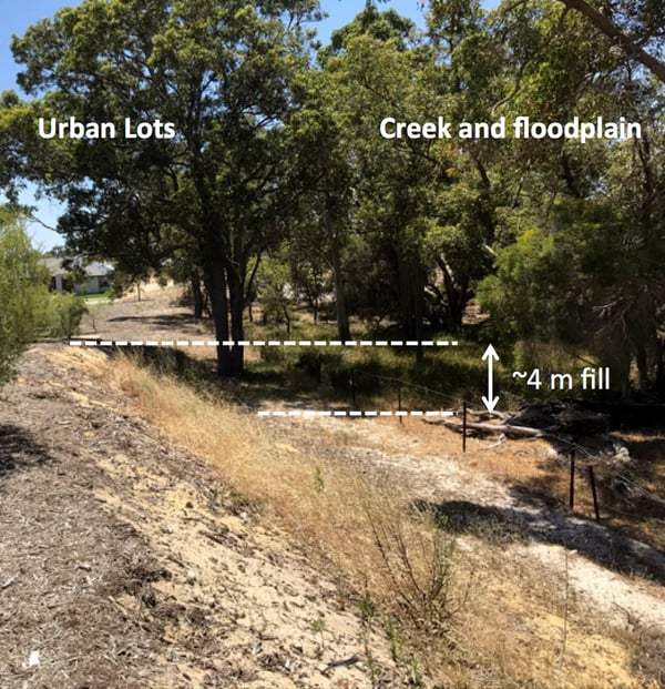 Figure 1: Illustration of extensive use of fill in a new urban development in Perth's North-Eastern Corridor. Abutting a creek, its floodplain and protected bushland, the developed land surface was elevated by as much as 4m above the natural land surface.
Minimising the use of fill represents a major opportunity to improve the management of high groundwater sites in the Perth area. However, LGAs often require a conservative approach, in which large volumes of fill provide a buffer between the developed land surface and the water table. This practice has a number of drawbacks for developers, home owners, and the environment (Claydon et al., 2020). Mitigating the risks associated with reduced fill depths could alleviate these problems, and represents an achievable pathway towards more sustainable development in high groundwater sites.
Conservative fill use can be thought of as a response both to “upstream” drivers within the developed lots and “downstream” drivers associated with water leaving these lots (Figure 2). Upstream drivers relate to allowing appropriate clearance between the phreatic surface of the groundwater and overlying urban infrastructure. Infrastructure includes roads, utility/pipe corridors, housing foundations and other “hard” components of the urban landscape that can be damaged by groundwater or by wetting/drying of underlying soil. These include vegetated areas, such as backyards or public open space, which do not fulfil their purpose if they are muddy, waterlogged, or form breeding sites for pests. Failing to keep these areas dry is a high-visibility and high-cost problem.
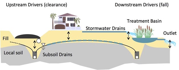 Figure 2: Schematic illustrating upstream and downstream drivers for using fill (yellow). Upstream, clearance between the groundwater and roads/utility corridors / housing foundations/yards/public open space, can require additional fill to be added. In this schematic, this is particularly needed because the peak groundwater mound (shown by the dashed blue line) would breach the natural land surface (grey) over a large part of the site. Downstream drivers are associated with the need for fall – here required in the design of a natural treatment train for stormwater. Wastewater and the subsoil drains can also impose requirements for additional fill in order to achieve required pipe gradients under gravity systems (not shown).
Resolving such problems is often expensive (see examples in Figure 3), and generally falls on homeowners or LGAs. Because LGAs are responsible for approving local urban stormwater management plans, they often require that development plans use a certain depth of fill. Whilst this is a conservative, risk-minimizing decision, it can result in the use of large volumes of fill.
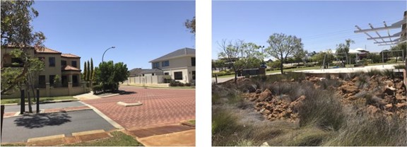 Figure 3: Sites where remediating damage caused by groundwater flooding has imposed significant costs on local government. On the left, the road intersection shown has had to be rebuilt following groundwater damage. On the right, public open space that routinely flooded with winter groundwater has been excavated and replaced by this rocky detention basin – at considerable expense, and to the detriment of the overall amenity of the green space.
Downstream drivers for using fill relate to the challenges of finding sufficient elevation differences to obtain fall and/or grade separations for hydraulic infrastructure including sewerage, stormwater conveyance and stormwater treatment. Drained groundwater from gravity-controlled subsoil drains and surface stormwater must be disposed of appropriately. Both water sources can contain elevated nitrogen or phosphorus, and therefore may require treatment prior to discharge. The vertical separation distances required to include treatment options, such as bioretention basins or vegetated swales within the development, require elevating the development site upstream of the treatment unit (see Figure 2). On relatively flat sites, this results in the use of large volumes of fill. “End of pipe” treatment approaches are particularly challenging, as they may require raising the entire site. These downstream drivers for fill are less visible to land owners than the upstream flood/waterlogging mitigation requirements, but they are important to land development consultants. Industry representatives are seeking better understanding of the benefits of “end of pipe” treatment of drainage waters, relative to the costs associated with increased volumes of fill.
The current development paradigm in high groundwater sites on the Swan Coastal Plain is predicated on using large volumes of fill both to minimise risk and to comply with urban runoff treatment requirements. However, as we elaborate below, this paradigm is neither environmentally nor economically benign. Indeed, shifting the development paradigm to one which minimises fill use, while mitigating the risks associated with this choice, offers numerous benefits to land developers, the environment, regulators and residents on the Swan Coastal Plain.
The economic, environmental and social problems of construction fill
From an economic standpoint, the excessive use of fill creates an unnecessary and disproportionate impact on house prices. On average, the cost of fill in Perth is approximately A$30/m3, and rising. Importing clean fill can consequently represent up to 30% of on-lot development costs, which are typically passed on to home buyers. New land developments are mostly located in outer suburban areas, offering lower-cost housing stock. Customers for this land often operate at the margins of affordability. As a result, even small increases in lot price may exclude some prospective buyers. A direct line can be drawn between extensive use of fill, increased lot development costs, and the affordability of home ownership. This represents a social justice argument for reducing fill use where possible.
Sourcing fill has environmental impacts. Fill comes from sand quarries, which typically require clearing of vegetation. Quarrying operations and haulage to development sites impose both carbon costs and the other disturbances such as noise, traffic, and wear and tear on roads. We are not aware of dedicated studies that quantify these impacts, but they would all scale directly with the quantity of fill required at a development site.
At the development site itself, a broad range of under-studied environmental impacts follow from extensive fill use. In the developed landscape, the variation of the land surface does not follow any geomorphic logic, but is discontinuous and incongruous across the boundaries of separate developments. These so-called “Frankenstein” landscapes (e.g. Figure 1) substantially reduce visual and physical amenity, and at times impose privacy and erosion concerns – e.g. where large grade separations occur between neighbouring developments. The use of fill also contributes to the loss of tree cover (Brunner & Cozens, 2013), as trees growing in the natural land surface cannot be retained if the surrounding land surface must be substantially raised.
Filled sites are often designed to drain internally to subsoils, but they also create a new land surface within which groundwater can mound. Due to the high permeability of sand fill, water table mounding is often established rapidly after development. The implications of this additional hydraulic head for groundwater flow and quality around developed lots are poorly understood. Examples can be found in the Perth area where wetlands or remnant bushland are encircled by developments with raised land surfaces (Figure 4). It is difficult to accept that this can occur without a cumulative adverse impact on groundwater processes in the encircled area. However, only anecdotal information describes wetlands’ responses to the cumulative impacts of urbanisation in many locations. Local urban water management plans and associated detailed modelling are typically required only at the level of subdivision planning (WAPC, 2008). Therefore, although some guidance is available, there is no planning mechanism routinely followed to formally assess and mitigate the cumulative impacts of fill use (DoW, 2008).
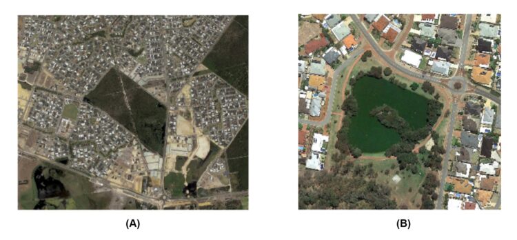 Figure 4: (A) An area in Perth surrounded by multiple urban developments, many of which used fill to elevate the land surface. (B) A lake in the greater Perth metropolitan region showing a green algal bloom. Eutrophication in the lake is primarily driven by groundwater inflows, and became problematic approximately 15-20 years following urbanisation of the surrounding area.
Elevating the land surface with fill also changes the shape, nature and connectivity of surface flow pathways. Fill is routinely used where high groundwater environments occur on floodplains. In these locations, fill may reduce floodplain storage or isolate the stream channel from the floodplain. The implications of such changes in connectivity and storage on extreme flood processes may be significant. As surface flood modelling and diagnostic approaches improve, estimates of the extent of floodplain areas are also changing. In some areas fill used for existing urban developments may have isolated stream channels from their floodplains (DWER, 2019). Mitigating the changing surface flood risks is costly. Moreover, fill use on floodplains entails a potentially complex trade-off between mitigating groundwater and surface water flood risks.
The use of fill has enabled the ongoing use of construction and design techniques that are increasingly poorly aligned with local site characteristics. In Perth, construction norms are predicated on a relatively deep groundwater level, overlain by sandy soil, allowing the use of thin slab foundations supporting double brick exteriors and tile roofs, with a flat grassy backyard. This ubiquitous design is not resilient to shallow groundwater flooding. The consequences of high groundwater within urban lots are therefore expensive for both homeowners and LGAs responsible for damaged assets. Yet alternative housing design and construction approaches are unfamiliar to most consumers. Perpetuation of the status quo in the industry makes it challenging to reform building and lot design approaches.
The joint economic, environmental and social impacts of fill suggest that there could be multiple benefits if urban development in the Swan Coastal Plain moved towards a paradigm of fill minimisation.
Recommendations
How could the use of fill be minimised?
Minimising the use of fill requires adopting a suite of achievable changes to current practice.
At the broadest level, detailed regional drainage and flood modelling studies should be extended across the development frontiers on the Swan Coastal Plain to better identify areas where the use of fill increases flood risk (e.g. due to disconnection of floodplains from channels). While the Western Australian Department of Water and Environmental Regulation (DWER) is undertaking such modelling in some regions of Perth, extending these efforts and linking them into a revision of existing planning frameworks would be valuable. At present, it is likely that some areas zoned for development may be subject to large, but poorly understood water management and environmental hazards.
For other sites with groundwater constraints, adopting the best-practice approaches for prediction outlined in Part 1 would provide a better characterization of groundwater risks, and likely allow for reductions in the margins of error associated with predictions. High quality site characterisation and modelling is a precursor to increasing the confidence of approving bodies in predictions and designs. This in turn would enable LGAs to move away from using conservative “rules of thumb” to specify fill depths.
High quality modelling would be complemented by designs that improve the robustness of urban development to periodically high groundwater conditions. There is a broad palette of options available to engineers, developers and builders to achieve this, as illustrated in Figure 5. For example, several practitioners routinely grade the surface of underlying clay (where present) towards subsoil drains. Imposing a bed slope on the impeding clay layer effectively increases the gradient of the groundwater flow path, enhancing the effectiveness of the subsoil drains (Figure 5 panel B). Other groundwater-based interventions could include installing on-lot subsoil drains to lower the back-of-lot groundwater mound and reduce flooding of gardens (Figure 5 Panel C). Preventing soakwell installation near this mound (i.e. enforcing soakwells at the front of lots), or even draining impervious areas directly to stormwater drains could also minimise groundwater rise at lot rears (Figure 5 Panel D). Alternatively, changes to design – whether using thicker slabs, adopting different foundation designs that are robust to wet soils, or altering yard design to raise beds or incorporate surface drains - are only some of the design options that could enable urban lots to “cope” with periodically wet soil conditions. Expertise to enact these kinds of innovations already exists within the Perth land development industry: the challenges that remain are those of incentivising, normalising or mandating these sorts of approaches on high groundwater lots.
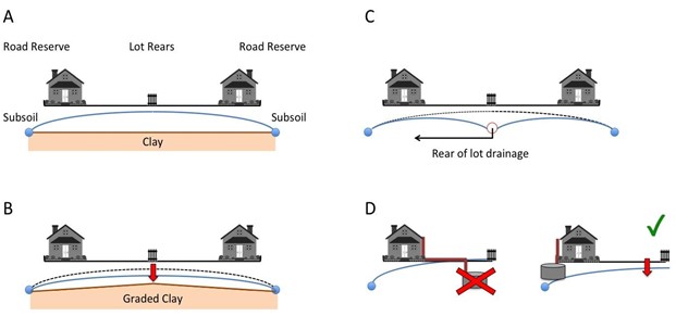 Figure 5: (A) Schematic of a groundwater mound forming at the rear of two urban lots. (B) Following grading of the clay downslope to the subsoil drains, the hydraulic gradient is increased and the peak groundwater level drops. (C) Installation of rear-of-lot-drainage would drain the mound, and (D) Installing soakwells near the subsoil drain (front of lot) rather than near the groundwater mound (rear of lot) promotes drainage and avoids exacerbating rear-of-lot flooding.
Innovating around the onsite treatment and reuse of drained subsurface water could also provide an avenue to reduce fill requirements by reducing the “downstream” demands for elevation (Barron et al., 2011). Innovations could include active pumping of groundwater, rather than relying on gravity drains; in-pipe treatment methods, water reclamation or using more distributed, smaller treatment options to replace end-of-pipe approaches. Many of these methods are already employed in the Perth region – although often they were installed to mitigate problems with end of pipe treatment. This kind of “remedial” use of alternative technologies can be costly, especially in areas with high nutrient content in the groundwater. However, these measures may be considerably more cost-effective if designed upfront and integrated into the overall development strategy for subdivisions.
What governance and cultural reforms could facilitate fill minimisation?
What is needed to realise these changes? We see four major governance and implementation challenges that need to be addressed in order to move towards a paradigm of minimising fill.
The first relates to the “chain of responsibility”. The subdivision and lot designs that are used to enable fill to be minimised must be adhered to at the construction stage. Minimising fill is likely to depend on multiple landowners adhering to specific water management requirements (e.g. placement of soakwells, design of gardens, etc.). At present, neither local government regulations nor state legislation provide mechanisms to enforce the implementation of these design features during construction. Often, different personnel and local government departments are responsible for building approvals and land development or water management approvals. However, if minimal fill designs are to be widely accepted, the LGAs approving designs will need confidence that construction will follow the approved design.
LGAs are also challenged by the technical complexity of water management approaches needed in high groundwater sites. A lack of technical background and suitable tools to evaluate designs, modelling and underpinning assumptions is a dominant theme amongst the concerns raised by local government representatives. Again, there is scope to innovate in order to build the needed capacity. For example, academia and local governments could partner to produce user-friendly free-ware tools that enable “sense checking” of proposed designs. Alternatively, existing structures such as the Metropolitan Regional Councils could support “expert hubs”, by employing dedicated groundwater experts to independently assess development proposals in challenging areas on behalf of local governments. These difficulties are widely recognised as a challenge to the success of decentralised decision-making for water management across Australia (Rijke et al., 2013). Supporting decision-making by LGAs is another pathway to build confidence in fill-minimising approaches.
During its study, the Expert Panel heard about a wide variety of water management, construction and design ideas proposed to make urban developments more robust to high groundwater. This suggests that there is a rich potential for innovation in this space. Currently, however, there appear to be roadblocks to implementation of these ideas. These ranged from obtaining financing for unconventionally constructed housing, to consumer preferences for familiar construction approaches, and a lack of awareness among builders and engineers regarding alternative design or construction techniques. These roadblocks suggest a valuable role for state government-supported demonstration sites in which innovative designs could be implemented, tested, evaluated and shared with potential builders and consumers.
Numerous state government land developments in Western Australia already act as exciting demonstration sites for sustainable development, urban water management, energy management and resilience (Development WA, 2021a, 2021b). However, none of these have been located specifically on a high groundwater site. There is ample scope for future state government land development projects to explore and demonstrate innovative groundwater management options, including trials of alternative water treatment options that reduce the need for fill. Approaches taken could be well informed by other work by the CRCWSC which has identified governance structures and strategies to support innovation and adoption (e.g. Bettini and Head 2016). Mechanisms for sharing risk between developers and government could also provide a useful pathway towards lowering the barriers to innovation – indeed such risk sharing features prominently as a catalyst for innovation in Water Sensitive Urban Design elsewhere in Australia (Farrelly & Davis, 2009).
Finally, there is a need to critically reappraise the timing of drainage and water management evaluation within the Western Australian planning process. This is evidenced by the environmental challenges emerging at some high groundwater sites in the Swan Coastal Plain and the difficulties associated with flood control following extensive use of fill in floodplain environments. This planning process requires different decisions about development to be made at distinct spatial scales and points along a development timeline. At the largest scale, regional and subregional plans identify where urban development can occur within a LGA (DPLH, 2018). The next level of detail is the local structure plan, which details the layout of suburbs, subdivisions or townsites, including where roads go, housing density and buffers (City of Cockburn, 2021).
Local water management strategies are currently initiated at this local structure planning stage. This is problematic for several reasons. Firstly, the scale is often too small to address regional water issues such as floodplain function or cumulative impacts of the use of fill. Thus, it promotes a piecemeal approach to water management, when water management in many sites includes extensive regional components. Secondly, there has often been significant investment in potential development sites before the necessary and appropriate urban water management plans are considered. If “deal breaker” issues are identified relating to water at this stage, developers are placed in a difficult situation due to sunk costs and hard-to-manage environmental risks. If these risks are not adequately managed, problems tend to arise post-development, exposing LGAs to liability.
Because water management is often only addressed in detail at the local structure planning or subdivision proposal stages, flood and drainage planning at regional scales is not addressed by developers. This means that risks arising from water management at these large scales will be assumed by approving authorities, infrastructure managers and land owners. Certain exceptions exist, for example, when state government agencies such as DWER undertake district level water planning in response to rezoning or potential flood risks at the structure plan level. At present, such detailed drainage and water management assessment is not available across the entirety of Perth’s urban development frontier. Therefore, sites zoned for development may face significant – potentially unacceptable – water-related risks. Bringing forward water management assessments earlier in the planning process and allowing water related risks to exclude some sites from urban development could help avoid significant social, economic and environmental costs flowing from these risks.
Conclusion
Fill is a valuable tool enabling urban development on the high groundwater environments of the Swan Coastal Plain, but its use entails significant economic, environmental and social costs. Moving to a paradigm of development that minimises the use of fill will reduce these costs. Such a paradigm of development is achievable by combining technical best-practice (Claydon et al., 2020; Thompson et al., 2021), with innovations in design and construction. Also necessary, however, will be measures that offer LGAs confidence in approving low-fill developments. LGAs are exposed to significant risk where groundwater management fails. Hence, LGAs require mechanisms to ensure consistency between plan designs and constructed allotments, and support in reviewing technically complex groundwater modelling. Barriers to innovation based on consumer and industry inertia can be lowered by demonstration projects, especially those led by the state government, which has a growing track record of excellence in urban water management. However, a broader governance challenge remains, regarding the timing and scale of water management assessments in the Western Australian urban planning process. Finally, regional water assessments are needed to improve our understanding of cumulative impacts of development on sensitive environments and flood risk in urbanised areas of the floodplain. As Perth encroaches on high groundwater regions, the findings of these assessments should be incorporated into land zoning and planning processes to limit some of the risks currently assumed by land owners and LGAs.
Acknowledgements
The authors deeply thank all study participants for their time and openness in sharing information. We would also like to thank the following organizations for their feedback and input: Urban Development Industry Association's (UDIA) Water Committee for WA, the multi-stakeholder Land Development in Groundwater Constrained Environments Steering Group (convened by the Institute of Public Works Engineering Australasia (IPWEA) WA branch and the Western Australian Local Governments Association - WALGA), the CRCWSC’s Western Region Advisory Panel and Perth’s Water Sensitive Transition Network. We also thank Prof. Carolyn Oldham from UWA, the CRCWSC’s project leader for IRP5, for her valuable feedback and support.
The research project was funded by Cooperative Research Centre for Water Sensitive Cities, Integrated Research Project 5 Stage 2. To contribute to this paper, Ana Manero was supported by the Australian Research Council, under project FL190100164.
About the authors
Sally Thompson | Sally Thompson is an Associate Professor of Environmental Engineering at the University of Western Australia. Sally is Editor in Chief of the Journal of Hydrology, holder of the US National Science Foundation’s CAREER Award and the American Geophysical Unions Early Career Hydrology Award.
Margaret Shanafield | Margaret Shanafield is a Senior Researcher and Senior Lecturer at the National Centre for Groundwater Research and Training and the College of Science and Engineering at Flinders University, in Adelaide, SA. Her research focusses on surface water-groundwater interactions. She is a 2020 South Australia Young Tall Poppy award winner and was the recipient of a 2015 Australian Research Council Discovery Early Career Research Award to investigate how rainfall becomes streamflow in intermittent rivers, and how this streamflow recharges our aquifers.
Ana Manero | Ana Manero post-doc research fellow at the ANU Crawford School of Public Policy, working on water economics and governance. Ana’s research interests are around water management and its socio-economic implications. Ana also holds an adjunct research fellow position at the University of Western Australia.
Greg Claydon | Greg Claydon is a member of the board of directors of the Cooperative Research Centre for Water Sensitive Cities (CRCWSC). Greg has extensive water industry knowledge, built through his roles as a senior executive with Queensland’s and Western Australia’s state government water, environment and natural resources agencies. In 2009, Greg was awarded a Public Service Medal (PSM) by the Governor-General of Australia in the Australia Day Honours Awards for outstanding public service in natural resources management and water reform.
References
ABC. (2021, 27 MarMarch 2021). Sewage spill caused by NSW floods forces evacuation at Stuarts Point on NSW Mid-North Coast. ABC. https://www.abc.net.au/news/2021-03-27/nsw-floods-sewage-spill-mid-north-coast/100033144
Ball, J., Babister, M., Nathan, R., Weeks, W., Weinmann, E., Retallick, M., Testoni, I., & (Editors). (2019). Australian Rainfall and Runoff. A Guide to Flood Estimation. Commonwealth of Australia (Geoscience Australia). http://book.arr.org.au.s3-website-ap-southeast-2.amazonaws.com/
Barron, O., Barr, A., Donn, M., & Pollock, D. (2011). Combined consideration for decentralised non-potable water supply from local groundwater and nutrient load reduction in urban drainage. Water Science and Technology, 63(6), 1289-1297. https://doi.org/10.2166/wst.2011.373
Bettini, Y and Head, B.W. (2016). Governance structures and strategies to support innovation and adaptability. Melbourne. Australia. Cooperative Centre for Water Sensitive Cities. https://watersensitivecities.org.au/wp-content/uploads/2016/07/A3.1.2.2016_Governance_structures_web.pdf
Brown, R. R., Rogers, B. C., & Werbeloff, L. (2016). Moving Towards Water Sensitive Cities: A Guidance Manual for Strategists and Policy Makers (1921912359). https://watersensitivecities.org.au/wp-content/uploads/2016/05/TMR_A4-1_MovingTowardWSC.pdf
Brunner, J., & Cozens, P. (2013). ‘Where have all the trees gone?’Urban consolidation and the demise of urban vegetation: a case study from Western Australia. Planning practice & research, 28(2), 231-255. https://doi.org/10.1080/02697459.2012.733525
City of Cockburn. (2021). Structure Plan Framework and Process. Retrieved 30 April 2021 from https://www.cockburn.wa.gov.au/Building-Planning-and-Roads/Town-Planning-and-Development/Structure-Plans/Structure-Plan-Framework-and-Process
Claydon, G., Thompson, S., Shanafield, M., & Manero, A. (2020). Guiding urban water management in areas that experience high seasonal groundwater: Expert Panel report. https://watersensitivecities.org.au/content/guiding-urban-water-management-in-areas-that-experience-high-seasonal-groundwater-expert-panel-report/
CRCWSC. (2017). Project IRP5. https://watersensitivecities.org.au/content/project-irp5/
Development WA. (2021a). OneOneFive Hamilton Hill. Retrieved January 12 from https://developmentwa.com.au/projects/residential/oneonefive-hamilton-hill/overview
Development WA. (2021b). WGV. Retrieved January 12 from https://developmentwa.com.au/projects/residential/white-gum-valley/overview
DoW. (2008). Urban water management plans Guidelines for preparing plans and for complying with subdivision conditions Government of Western Australia. https://www.water.wa.gov.au/__data/assets/pdf_file/0014/4217/82685.pdf
DPLH. (2018). Region planning schemes. Retrieved 30 April 2021 from https://www.dplh.wa.gov.au/information-and-services/district-and-regional-planning/region-planning-schemes
DWER. (2019). Operational Performance Report 2018-2019. https://dwer.wa.gov.au/sites/default/files/DWER_AR_2018-19_02_Operational_Performance.pdf
Fan, Y., Li, H., & Miguez-Macho, G. (2013). Global Patterns of Groundwater Table Depth. Science, 339(6122), 940-943. https://doi.org/10.1126/science.1229881
Farrelly, M., & Davis, C. (2009). Demonstration Projects: Case Studies from Melbourne, Australia. N. U. W. G. P. M. University. https://www3.monash.edu.au/fawb/publications/demo-project-melbourne.pdf
GHD, Water Technology, & The University of Western Australia. (2018). Integrated Research Project 5: Knowledge based water sensitive solutions for development in high groundwater environments. Stage 1 report. https://watersensitivecities.org.au/wp-content/uploads/2018/07/att10_IRP5_Stage1-version2.pdf
Palinkas, L. A., Horwitz, S. M., Green, C. A., Wisdom, J. P., Duan, N., & Hoagwood, K. (2015). Purposeful Sampling for Qualitative Data Collection and Analysis in Mixed Method Implementation Research. Administration and policy in mental health, 42(5), 533-544. https://doi.org/10.1007/s10488-013-0528-y
Radcliffe, J. C. (2019). History of water sensitive urban design/low impact development adoption in Australia and internationally. In Approaches to Water Sensitive Urban Design (pp. 1-24). Elsevier. https://doi.org/10.1016/B978-0-12-812843-5.00001-0
Richts, A., Struckmeier, W. F., & Zaepke, M. (2011). WHYMAP and the Groundwater Resources Map of the World 1:25,000,000. In J. A. A. Jones (Ed.), Sustaining Groundwater Resources: A Critical Element in the Global Water Crisis (pp. 159-173). Springer Netherlands. https://doi.org/10.1007/978-90-481-3426-7_10
Rijke, J., Farrelly, M., Brown, R., & Zevenbergen, C. (2013, 2013/01/01/). Configuring transformative governance to enhance resilient urban water systems. Environmental Science & Policy, 25, 62-72. https://doi.org/10.1016/j.envsci.2012.09.012
Thompson, S., Shanafield, M., Manero, A., & Claydon, G. (2021). Urban stormwater management in areas of high groundwater – Part 1: Guiding predictions. Water e-Journal. Volume 6, No 1 2021, https://doi.org/10.21139/wej.2021.006
WAPC. (2008). Better Urban Water Management. Western Australian Planning Commission. https://www.water.wa.gov.au/__data/assets/pdf_file/0003/1668/82305.pdf

